https://link.brightcove.com/services/player/?bctid=4416209319001
Above: A short film captured from the chopper when AP joined the Network Rail team
In a previous incarnation, Sean checked trackside fencing and vegetation for Network Rail.
Now, the body responsible for maintaining Britain’s railway lines employs him as an aerial-survey specialist – using his skills as an ‘off-track’ engineer to capture fault-finding photographs from 1,000ft (300 metres) up.
He is one of two Network Rail ‘observers’ taking to the skies over London and the South East, on a mission to spot any glitches on the line such as a loose bolt, a rogue sleeper or a flood risk before they pose a danger.
The other observer, Tony Calvino, was previously deployed as a mobile operator, dealing with points failures and fatalities on the line – of which there are around three or four per week, nationwide.
In June, the London and South East (LSE) Helicopter Programme clocked up over 53 flying hours in 26 days, losing only three days to poor weather.
The air miles yield results. Since it was formed in 2012, the LSE project has reported almost 1,500 ‘potential faults’.
One Network Rail helicopter is dedicated to London and the South East, while another patrols the rest of the country.
The choppers came into their own during the 2012 London Olympics, when three were used to spot vandals and trespassers on the lines, helping to ensure the network was fully fit to cope with extra traffic generated by the Games. They could also convey spare parts.
It’s a far cry from the days when a surveyor was limited to walking the lines armed with a thermal-imaging camera.
‘Handheld cameras are still used, but the helicopter can help channel the efforts of the guys on the ground,’ said Network Rail communications manager Chris Denham.
Lenses on the line
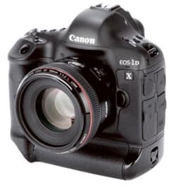
The team frequently arm themselves with a Canon EOS-1D X DSLR, pairing it with a 28-300mm f/3.5-5.6L IS USM lens to shoot from a specially designed window that opens on the port side of their twin-engined helicopter.
 The aerial photographers, including Sean Leahy pictured here, also use a mounting on the outside of the chopper. It houses a Canon EOS-1D C, or a thermal-imaging camera [Credit: C Cheesman]
The Canon kit has been used to take thousands of photographs. Geotechnical engineers say they can tell a lot about a problem on the ground, from above. ‘Our chopper was used last year to view the landslip sites at Robertsbridge [in East Sussex],’ explained Denham.
‘The geotech guys were able to see the surrounding landscape and the effects of the slips.
‘We were also called to the Harbury Slip site [in Warwickshire], regularly fly the White Cliffs at Dover [in Kent] and [over] ground-works, post-flooding and extreme weather.’
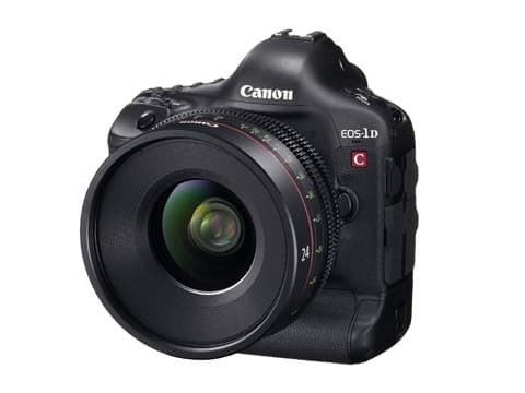
However, on this assignment the team – dubbed ‘air-ops’ – will be using a Canon EOS-1D C mounted on the outside nose of the helicopter (see above).
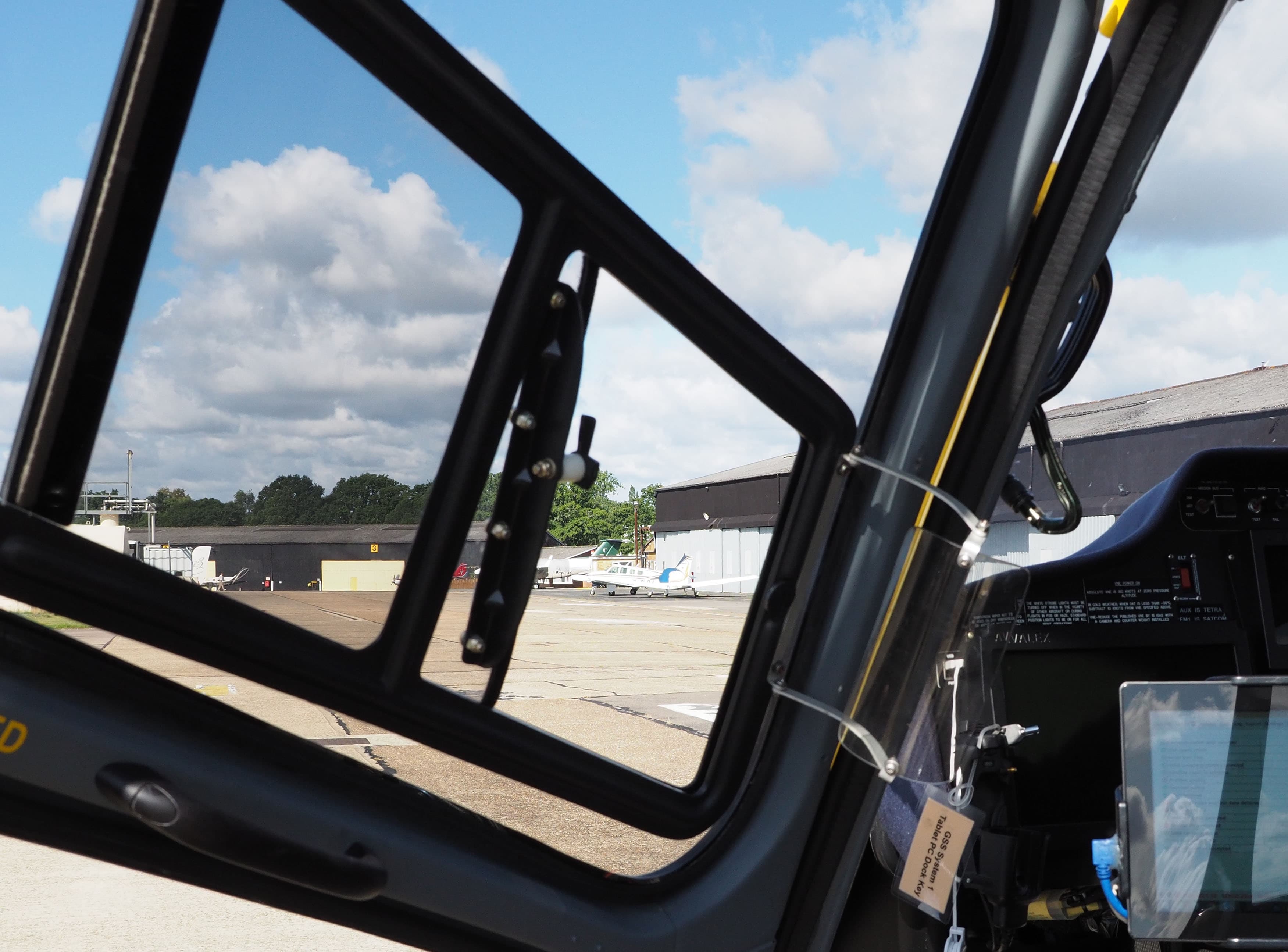 A specially designed window opens to allow the aerial survey specialist to shoot through it using a Canon EOS-1D X, which is secured from inside the aircraft [Credit: C Cheesman]
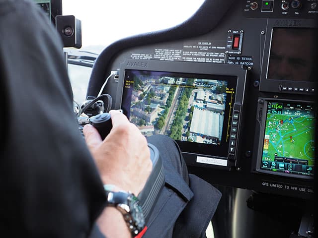 Sean Leahy controls the Canon EOS-1D C from inside the cabin [Credit: C Cheesman]
Eyes in the sky
The team have experimented with various cameras over the years, including a Phase One medium-format model. At one time they even tried to get to grips with a 1,000mm lens, but the rocket-sized optic had to be tied down with bungee cords and was just not practical to use inside the cockpit.
 The 1D X gives the team ‘freedom’ they are after, because it can be used inside the cabin and taken to wherever pictures of the network may be needed at a moment’s notice.
The 18-million-pixel full-frame camera is rugged and built for the job, enthuses Sean, as the team prepare for action at their helicopter base, Fairoaks Airport in Chobham, Surrey.
The 84-year-old airfield is strewn with the playthings of jet-set millionaires, but otherwise looks to have changed little since it was used to train 6,000 pilots and repair planes during the Second World War.
Network Rail’s home is far from glamorous, being tucked away in a distinctly un-glitzy building tagged onto the side of an aircraft hangar.
Among those inside is today’s observer, Sean, a self-taught photographer who, from a glance at the photographs of planes on his computer tablet, is clearly an accomplished picture-taker away from the office.
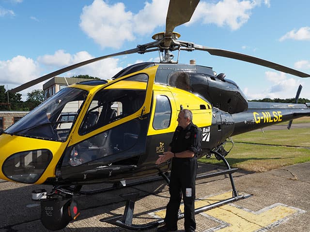
The office, in Sean’s case, is an AS355 Twin Squirrel helicopter, emblazoned with the ‘Network Rail’ logo and looking particularly smart and shiny on this bright Thursday morning in late July.
The chopper, which Sean says he spruces up himself, covers a vast swathe of southern England, including north, west and south London.
‘I do 10 days on with four days off,’ explained Sean, who spends much of his spare time photographing planes at airshows.
Seven of Sean’s 10 working days are spent flying – setting off from Fairoaks, or from Rochester in Kent which takes in the eastern fringes of the region, including East Anglia.
 Sean Leahy, one of the Network Rail photographers, also known as ‘observers’ [Credit: C Cheesman]
A track codenamed ‘XTD’
Sitting alongside Sean will be today’s pilot, Jan Hallam, who has been flying choppers for 20 years and is contracted to work for Network Rail from PDG, a helicopter operator.
Jan briefs the team on the route, which is through the Surrey countryside, across south London to London Bridge, commanding attention from the three passengers who today include a different kind of observer – Amateur Photographer news editor Chris Cheesman.
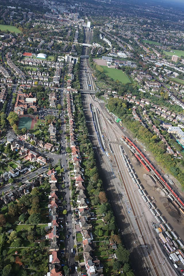
This morning’s target is a railway line with the code ‘XTD’ – known more prosaically as the track between East Croydon and London Bridge.
The military routine extends beyond the pre-flight safety briefing.
A strict part of the team’s itinerary, once airborne, is aligning the camera of choice to the satellite system, enabling it to record with pinpoint accuracy the recorded location of the photographs, to within inches.
Calibration requires the observer to spend 20 minutes or so hovering over a nearby landmark, taking eight shots at different points – today’s target being a local service station.
Once completed, Sean displays the skills of an aerial reconnaissance expert over his assigned territory, pointing out various landmarks en route, including the old Brooklands motor-racing circuit near Weybridge in Surrey and the forlorn site of what remains of the airfield at the first London Airport – a small patch of tarmac in Croydon.
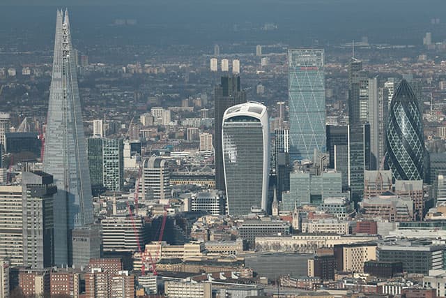 View of the City, captured using a Canon EOS-1D C and 300mm f/2.8L IS II USM lens [Credit: Network Rail]
Any route over London must be planned with care, given the closely monitored airspace of the capital, without breaching security.
As we flew over the city it was somewhat disconcerting to hear, over the pilot’s radio, that an Apache helicopter was behind as we journeyed upriver – although it was some way off and there was nothing untoward.
 Flying over Westminster on the return trip to Network Rail’s base in Surrey [Credit: C Cheesman]
On one eventful mission, Tony spotted a pair of birds’ nests on top of an overhead electrical gantry at Manor Park in east London.
Tony’s actions ensured the homes of the feathered thrill-seekers could be brought down before they caused any disruption.
‘While they don’t appear to be an issue currently, left unchecked they could cause could problems, so this was raised as a fault,’ recounted the team in its June newsletter.
‘Military-spec’ Google Maps
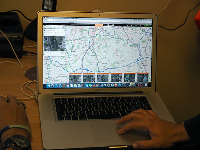
Back on the ground, acronyms abound. Potential faults on the line are first reported to the ICC (Infrastructure Control Centre) before being sent to the FMS (Fault Management System).
 [Credit: C Cheesman]
Staff at Network Rail delivery depots can then track the data using iPads. ‘Faults are geotagged, so your iPad’s GPS will tell you when you are in the right place,’ explained Chris Denham.
‘The program we use also shows all the previous faults in the same area, so they can instantly see if a problem is recurring, or likely to be related to something else.’
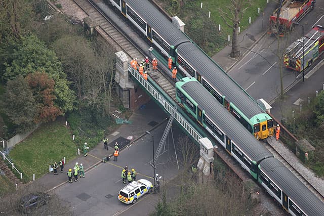 Aerial photography allows Network Rail to assess any damage to a bridge near Norwood in south London, after it was hit by a lorry [Credit: Network Rail]
Sean, who has no formal photography training, uploads his JPEG files to Route View, Network Rail’s ‘military-spec’ version of Google Maps, which it regularly updates to provide a ‘very high-quality overhead view of the whole network’.
Anything urgent spotted from the air is immediately relayed to the national operations centre at Milton Keynes in Buckinghamshire, by radio or satellite phone direct from the aircraft.
The photographers’ images are stored on memory cards before being downloaded and backed up on 4TB-capacity hard drives.
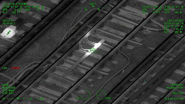 The crew’s armoury includes a thermal-imaging camera. This photo reveals overheating cables, normally a sign that electricity is struggling to flow properly and will eventually arc across the gap – leading the ‘cable or the sleepers to catch fire’ [Credit: Network Rail]
Not only are the aerial shots used to flag potential dangers, but they also help railway bosses in other areas.
Data gleaned from images can be used to extract distance information between various railway features – something not possible from old records.
This allows managers to gauge if there’s enough space alongside a railway line to allow staff to be safely despatched trackside, for example.
 [Credit: Network Rail]
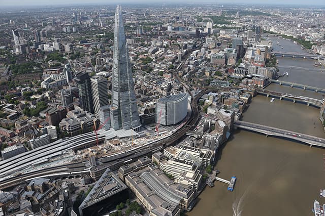
It’s not just close-ups of railway lines that are photographed, though. The team recently captured stunning aerial images of the Shard as part of a project to promote Network Rail’s ongoing £6.5 billion redevelopment of London Bridge station.
London’s oldest station has been partly closed since early 2015 and the butt of many negative headlines.
When it reopens in 2018, the London Bridge concourse will be trumpeted as Britain’s biggest – the size of the pitch at Wembley Stadium, apparently.
The completion will be welcomed by millions of commuters who have endured four years of disruption to their daily journeys and for whom a Network Rail helicopter with a cruising speed of 120mph would be like a gift from the heavens.
It will largely be in the hands of the eagle-eyed surveyors patrolling the skies above the capital to ensure the network runs smoothly from there on in – and escape the, no doubt, all-too-tempting headline ‘Network Fail’.
What else is in the ‘air-ops’ kitbag?
The team also use a Star Safire thermal-imaging camera that can detect faults with electrical equipment, as well as shoot HD video.
The thermal-imaging camera is mounted on the nose of the chopper, explained the team which is led by Eleanor Lloyd.
When AP joined the team, instead of the EOS-1D X Sean Leahy used a gyro-stabilised camera in the shape of a Canon EOS-1D C which was attached to the outside of the aircraft in the mount otherwise occupied by the thermal-imaging camera.
Sean was able to control the camera from inside the aircraft. The EOS-1D C has fittings for lenses ranging from 85mm to 600mm – or 840mm with a 1.4x extender.
Air-ops turns to the trusty EOS-1D X when the EOS-1D C is not being used. They can use the EOS-1D X inside the cabin and save an hour of valuable air time that would be eaten up by swapping the thermal camera for the EOS-1D C, which has to be done on the ground.
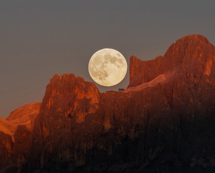
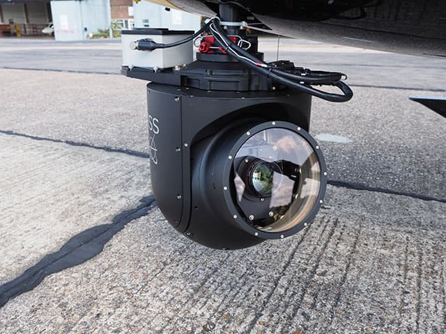 An exterior gimbal mounting is used to house either the EOS-1D C or a thermal-imaging camera [Credit: C Cheesman]
 Sean Leahy after the flight to London Bridge [Credit: C Cheesman]
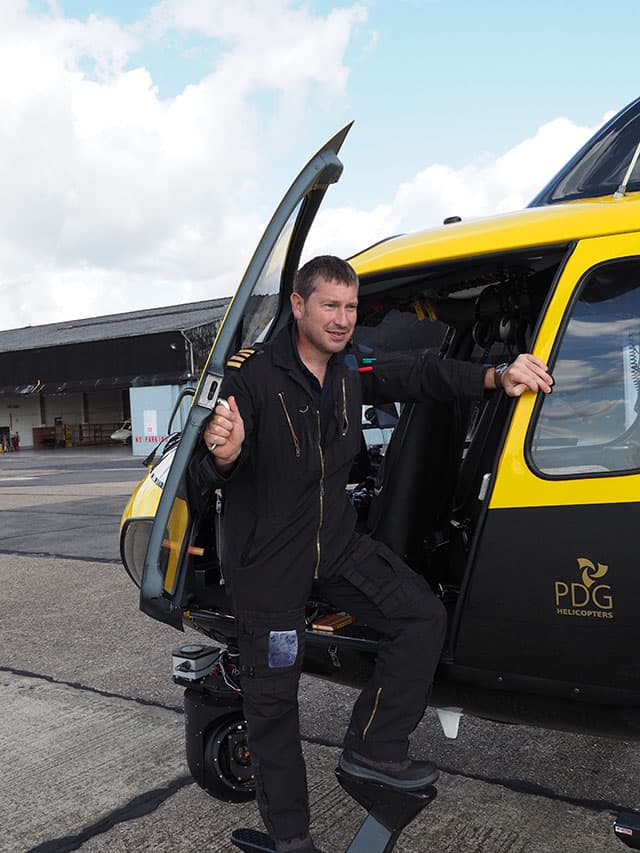 Pilot Jan Hallam [Credit: C Cheesman]
 The Acton Dive Under is a crucial part of London’s Crossrail project. It allows freight trains to access sidings without interfering with passenger trains – which ‘dive under’ the freight train access. This was shot using the Canon EOS-1D X and 28-300mm lens [Credit: Network Rail]